Explore, Adventure, and Unwind
About the Virgin Islands National Park
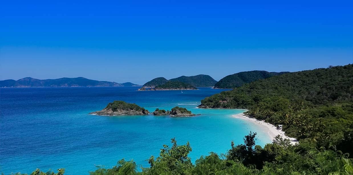
The Virgin Islands National Park on St. John encompasses miles of lush forest, historic plantation ruins, pristine beaches and coral reefs teaming with marine life. Trails weave by scenic lookout points, many ending at the shoreline of a wonderful beach. Sun seekers will be delighted by the beaches on St. John, which are some of the most beautiful in the Caribbean.
The park is well developed, which makes exploring the historical sites, beaches, and hiking trails easy and rewarding. You can enjoy the National Park by boat, camping, fishing, kayaking, hiking, scuba diving, snorkeling, swimming, and bird watching! Read more about the amazing activities in the National Park.
Historical Sites
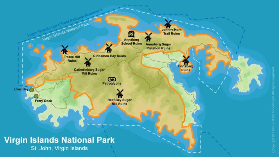
The National Park on St. John is a treasure trove of historical sites & ruins that offer a glimpse into the island’s rich and complex past. The Annaberg Plantation, the park’s most accessible historic plantation site, allows visitors to tour the sugar factory, animal mill, and windmill. The Cinnamon Bay area, home to early indigenous Taino people and later a Danish colonial plantation, offers insights into the island’s diverse cultural history. Catherineberg Plantation showcases well-preserved Danish colonial period sites, while the Reef Bay trail takes visitors past ancient rock carvings, Danish sugar plantation ruins, and hand stacked stone walls. These historical sites provide a tangible connection to the island’s past, from the pre-Columbian era to the Danish colonial period and beyond.
National Park Beaches
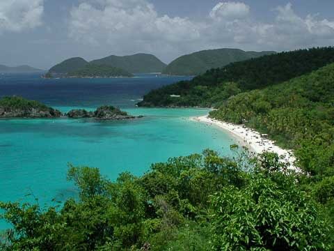
The Virgin Islands National Park is also home to some of the most stunning beaches in the Virgin Islands, each with its own unique charm. Trunk Bay, the most popular and most photographed beach in the park, offers white sand, towering palms, crystal clear water, and an underwater snorkeling trail. Maho Bay is a family favorite, with its convenient northside location, shallow waters, and seagrass beds that are home to sea turtles, rays, and tarpon. Cinnamon Bay, the longest white sand beach on St. John, offers a unique camping experience with its newly upgraded eco-tents and cottages. Lastly, secluded Salt Pond Bay offers a more remote atmosphere and fantastic snorkeling opportunities. Each beach, protected by the Virgin Islands National Park, offers a unique experience, making them must-visit destinations.
National Park Hiking Trails
St. John has over 22 different hiking trails within the park boundaries, each with its own difficulty and length, enabling you to access attractions off the beaten path. The Reef Bay Trail, for instance, takes hikers through a tropical forest, past petroglyphs, and down to an old sugar mill near a beautiful beach. The Cinnamon Bay Trail, on the other hand, begins near the Cinnamon Bay campground and leads up an old Danish plantation road, offering a glimpse into the island’s history. While the Lind Point Trail connects the National Park Visitor Center in Cruz Bay with Honeymoon Beach and Caneel Bay, providing stunning views from the Lind Point overlook,. The Bordeaux Mountain Trail is a challenging hike that connects the lush Bordeaux Mountain Road with Lameshur Bay 1000 feet below, offering a rewarding view from the highest point on the island. Each trail in the park offers a unique experience, whether it’s exploring historical sites, enjoying the island’s flora and fauna, or taking in the breathtaking views of the Caribbean Sea. Read The Complete Guide to Hiking on St. John
National Park Entrance Fee
Trunk Bay Entrance Fee
The nominal entrance fee to enter Trunk Bay helps preserve this natural wonder for future generations. Enjoy its beauty while contributing to its conservation.
Virgin Islands National Park
Address:
1300 Cruz Bay Creek
St. John, VI 00830
Donations accepted at: Cruz Bay Visitor Center
Telephone: (340) 776-6201
- $5per person
Interagency Senior Pass & Access Pass
These passes provide discounted access for U.S. citizens or permanent residents who are 62 years or older (Senior Pass), or who have a permanent disability (Access Pass).
$2.5per holder- Free
Mooring Fees
Overnight mooring fees must be paid prior to spending the night. Overnight stays are limited to 7 nights per bay and no more than 30 nights per year. Payment stations can be found at the following locations: Cruz Bay Finger Pier, Caneel Bay, Francis Bay, Leinster Bay, Saltpond Bay, and Great Lameshur Bay.
$26per night
St. John Off The Beaten Track
Over 200 full color photos
Your guide to the beaches, trails, and hidden attractions of St. John, U.S. Virgin Islands. Find quiet beaches, the best snorkeling spots, and abandoned sugar estates. Learn about the island’s history, geology, culture, people, ecology, plants and animals.
Order Today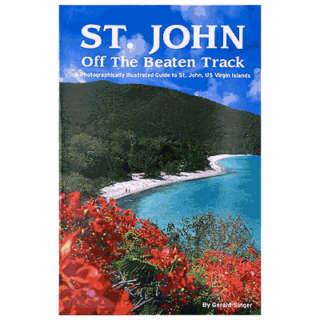
History of the Virgin Islands National Park
The Birth of Virgin Islands National Park: The Vision of Lawrence Rockefeller
In 1956 Lawrence Rockefeller, through the non-profit organization Jackson Hole Inc., donated 5000 acres of land on St. John to the National Park Service. On August 2nd of the same year United States Congress passed legislation to establish the Virgin Islands National Park. The legislation stipulated that the Park’s holdings on St. John could not exceed 9,485 acres. Today the National Park on St. John contains a total of 12,500 acres above and below the water.
Expansion and Inclusion of Submerged Lands
In 1962, the boundaries of the Virgin Islands National Park were expanded to include 5,650 acres of submerged lands off of St. John. This expansion was significant as it included a substantial amount of coral reefs, shorelines, and marine life, all of which are crucial to the biodiversity of the region.
The submerged lands have a diverse array of marine life, including various species of fish, sea turtles, and a multitude of coral species. The inclusion of these areas in the park’s boundaries ensures their protection and conservation, contributing to the overall health of the Caribbean Sea’s ecosystem.
The expansion of the park’s boundaries to include submerged lands was a pioneering move in the field of marine conservation. It highlighted the importance of protecting not just terrestrial ecosystems, but also marine environments, which are often overlooked in conservation efforts.
The Virgin Islands Coral Reef National Monument: A New Era of Preservation
In 2001 the Virgin Islands Coral Reef National Monument was established from 12,708 acres of federally owned submerged lands off the island of St. John. This area, administered by the National Park Service, protects coral reef and mangrove habitat crucial for the biological diversity of the entire Caribbean. These initiatives underscore the commitment to protect not just terrestrial, but also marine environments in the Virgin Islands.
Hassel Island: The Latest Addition to the Virgin Islands National Park
Hassel Island, once a peninsula of Saint Thomas, was separated by the Danish government in 1860 and later donated to the Virgin Islands National Park in 1978. This small island, located in St. Thomas’ Charlotte Amalie Harbor, holds a rich history that spans from the 1600s to the mid-1900s, including military, commercial, and agricultural activities. The Danish and British used the island’s strategic location for defense, and it was home to one of the earliest steam-powered marine railways in the western hemisphere.
Today, Hassel Island is a unique part of the Virgin Islands National Park, offering a diverse perspective on the region’s history. Efforts are ongoing to restore and preserve the island’s historic sites, ensuring its rich heritage continues to be a part of the Virgin Islands’ story.